The Panther Creek Falls Trail is a popular swimming/camping/hiking spot in Northeast Georgia – for good reason. It is beautiful. It also provides some unique and challenging terrain.

Details:
- Name: Upper Falls Via Panther Creek Trail
- Specs: Approximately 7 miles. 860 ft elevation gain. Moderate. Technical.
- Address: 4061 Old Historic 441, Clarkesville, GA.
- Parking fees: $4
- Foot Traffic: Busy. You will encounter plenty of other hikers even on weekdays.
- Restrooms: Pit toilets at the recreation area parking lot. Please do not leave TP at the falls; pack it out.
- Cell Service: Spotty at best.
- Time Required to Complete: Approximately 4-4.5 hours depending on how long you spend at the falls.

Trail Journal
Getting There
Be sure to check the GPS. Some programs list this as a Clarkesville address, others as Turnerville. You want the Panther Creek Recreation Area on Old Historic Hwy 441. There is a small gravel lot at the road or you may park in the paved lot. It is unclear whether payment is required for parking out at the road. The fee box is at the entrance to the parking lot. On weekends there will be vehicles lined up on the grass along both sides of the road.
There is a very shady picnic area here. It is rather buggy in summer and the scent of pit toilets will waft through occasionally. The river is pretty, though.
The Trail
The trail starts out with plenty of rocks and roots. After passing beneath Hwy 441, the noisy traffic fades and the only sounds will be the rushing of the river below, the singing of the birds above, and the friendly chattering of hiking companions. There are a couple of brief, sunny sections but the trees provide welcome relief from the heat.


At approximately 1.5 miles there is a wide, flat campsite along the river. Just beyond that there used to be a bridge across Panther Creek. That is long gone. While it is possible to cross where the bridge was, we find it safer and easier to go back to the campsite and cross there. Some members of our group balance on the rocks and logs. Those with water shoes/sandals simply wade across. The water is about knee deep on this day and feels incredibly refreshing.

At this point the trail immediately becomes mostly flat and sandy for about a mile or so. It is shady. The air is warm and humid, but every so often we feel a spot of coolness like walking past an open refrigerator door. We catch the scent of damp moss and hear the quiet burbling of a stream as it greets the river.


The Last Mile
The last mile to the falls becomes more technically challenging as the trail climbs up the side of a mountain overlooking the top of the falls. It is a little precarious in places as the path has literally been cut out of the rock. A cable hand rail is helpful and feels secure despite the fact that a few of the posts now dangle over the edge. A rope has been strung to help hikers pull themselves over one small washout.


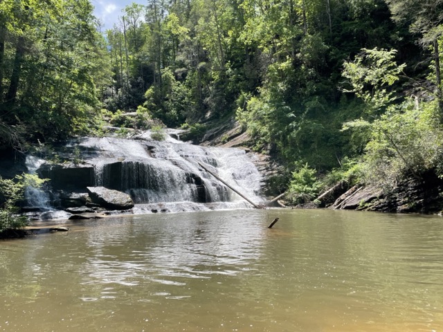
The Falls
We stand for a moment at the top of the falls and listen to the roar of the water. Then we descend to the sandy beach area with a lovely swimming hole. There are several fire pits here but no other hikers at the moment. Fallen trees provide seating for some and balance beams for others. A cool mist drifts off the falls as we enjoy our lunches.
After eating we wade, swim, skip rocks, or simply bask in the sunshine. Some challenge themselves (and worry their mothers) by climbing on the rocks and standing under the falls. We are blessed to spend our afternoon at such a place.
The Flora and Fauna
On this day, the mountain laurel is in full bloom! It is gorgeous. It covers the hillsides and arches over our path. A few rhododendrons are spotted as well as several other wildflowers. We see two (non-venomous) snakes, several slugs, and a snail.


Have you hiked to Panther Creek Falls? What is your favorite part?