The Opossum Creek Falls Trail in northwestern South Carolina is a beautiful, quiet hike featuring a sandy beach and a secluded waterfall.
(Sidenote: Apparently spelling is not a priority in South Carolina? I saw road and trail signs with ‘Oppossum,’ ‘Opossum,’ and ‘Opposum.’ It was about to drive me batty. Haha!)

Details:
- Name: Opossum Creek Falls Trail
- Specs: 5.5 miles total, 837 ft elevation gain, moderate.
- Address: Turkey Ridge Road, Long Creek, SC. (see notes below)
- Parking fees: $0
- Facilities: No potties here. (Please pack out your TP rather than adding to what has been tossed near the parking area. Some people are so gross!)
- Traffic: On a Thursday morning in September, from the parking area to the river we did not see another hiker. From the river to the falls, there was plenty of foot traffic as it is a popular stop for rafting groups. I can see where this trail would be busy on summer weekends.
- Cell Service: Excellent at trailhead. Spotty when traveling to trailhead and when on trail.


Journal:
Getting There
First, one must arrive at the correct location at the correct time – which is not as easy as it sounds. Some members of our group had trouble with Apple Maps and others had trouble with Google Maps.
Google took one family in a circle around Long Creek. (“Hey look kids, there’s Big Ben, and there’s Parliament!”) Thankfully, they only passed the general store once. And they did eventually arrive at the trailhead.
Apple Maps, on the other hand, apparently did not know that it is possible to drive on Turkey Ridge Road. It is gravel but easily passable – even in a car or minivan. That knocked 35 minutes off the estimated travel time. Members who used Apple arrived 35 minutes earlier than they anticipated. However some members saw the estimated travel time and chose not to join us for this hike at all. They were quite frustrated when we discovered the discrepancy and that they could have hiked that day.
So, the coordinates to the intersection of Turkey Ridge and Battle Creek Road are: 34.762115, -83.297114. Route yourself there and then estimate another 5 minutes to the trailhead from that point. The trailhead will be a mile or so up the gravel road, on the left. The parking area is just beyond that on the right.
The Hike
The trail parallels the road for a short distance before turning deeper into the woods and into a long gorge. The descent is not terribly steep. The path is mostly dirt with some gravel. It is a bit overgrown in many sections, but easily navigated as it is well trod and well marked. The entire trail is shaded at this time of year.
There are a couple of small rock scrambles and blowdowns. At one point, the gentlemen in our group push some downed branches off to the side of the trail for us. If I hike it again in summer, I might bring a machete for some minor trail maintenance – mostly to chop encroaching weeds. Those will be dying back soon.
Approximately 2 miles in we reach the Chatooga River – which is the border between South Carolina and Georgia. We meet a group of rafters who are just finishing their lunch break. They fall in behind us as we turn to our left and follow the trail up to the falls.
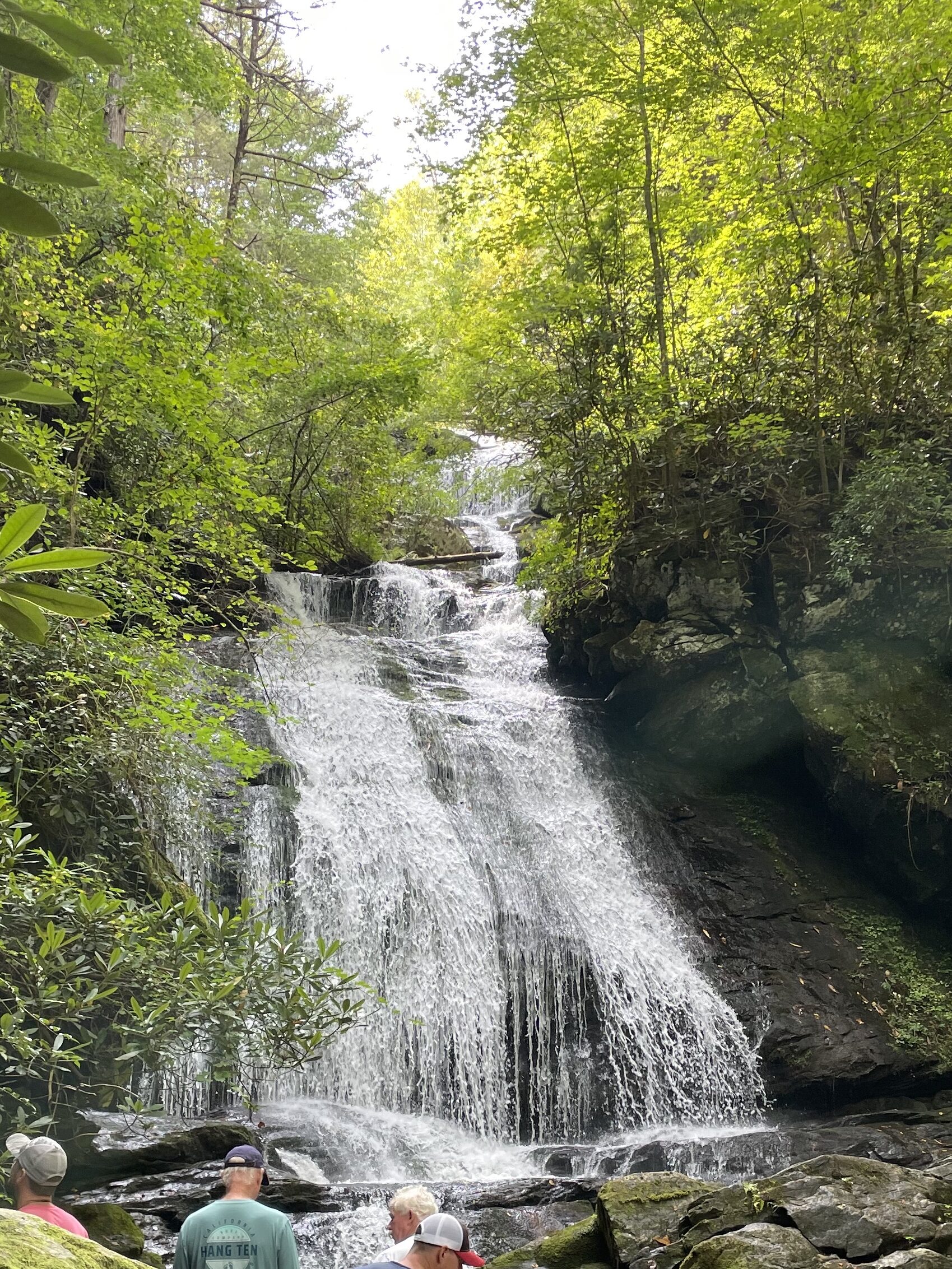
The Falls
The falls are approximately 1/2 mile beyond the beach area. This part of the trail follows Opossum Creek rather closely. We hear the water burbling and even rushing along next to us.
There is one water crossing between the beach and the falls. It is possible to tiptoe over the rocks and stay completely dry. However the water on the upstream side is only ankle deep and the bottom is mostly sand, not wobbly rocks. It feels quite refreshing for those of us who do not mind getting our feet wet.
We must scramble over some significant boulders to reach the bottom of the falls. The view is entirely worth the effort.
Lunch
There is no good place to swim at the falls. The banks are also not conducive to picnicking. So our group returns to the river to enjoy lunch and wade or swim.
To access the beach area we must cross the creek. Some balance on a log which spans a shallow (3 ft deep) gorge. The rest of us climb over several large, downed trees and then wade across a shallow, rocky section where the creek flows into the river.
On the other side is a beautiful sandbar which juts out into the river. Some of the kids wade and swim in the cool water. Others seek out some excellent skipping rocks. We can see a good swimming hole near the opposite bank. We also see turtles sunbathing on rocks both upriver and downriver from us.
The Return
After a nice rest, we gather our gear and our group to prepare for the hike out. The first mile is more difficult than the second mile. Even so, it is not too strenuous. Being September, the air is definitely cooler and slightly less humid than it was in August. We are thankful for that.
We all agree that we would love to hike this trail again – both in winter and in summer.
The entire hike, including a leisurely lunch, took our group 3.5 hours. Obviously, we would want to allow for more swim time in the summer months.


One response to “Opossum Creek Falls Trail”
Hi! I could have sworn I’ve been to this website before but after reading through some of
the post I realized it’s new to me. Anyhow, I’m definitely glad I found it and I’ll be bookmarking and checking back
frequently!